|
|
 |
|
Viewing report
|
|
 |
 |
European Wind Farm Map, 4th Edition
La Tene Maps, March 2011, Pages: 1
European Wind Farm Map - 4th edition, March 2011.
The European Wind Farm Map is another first for La Tene Maps. 
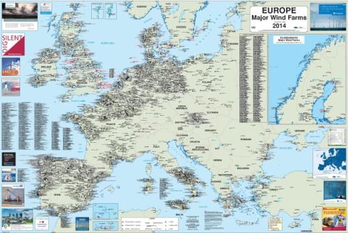
This map is published in association with the European Wind Energy Association.
This very big map shows the location, generation capacity and owner of the all wind farms over 1.2MW for Europe. Some smaller farms are shown space permitting. For Netherlands, Germany and Denmark some sites in the 1.2-2.0MW range have been removed. This is due to space restrictions more than anything else. The map shows wind farms in place and those under construction. Both onshore and offshore are dealt with. This map is available free to Members of the EWEA and the national Wind Energy Associations directly from their respective association
Printed Version: B0 + size (1198 x 1590mm)
Digital Version: Based on the printed version March 2011. The map is available in PDF format. The PDF version contains more data than the printed map as the text can be smaller. Also more of the smaller farms have been included
Product samples
A sample for this product is available. Please Login/Register to download this sample.
Customers who bought this item also bought
2010-2014 Deep Research Report on Global and China Offshore Wind Energy
Wind Energy - Global Strategic Business Report
European Offshore Windfarm Operations & Maintenance - Benchmarks, Costs and Best Practices for Current and Future Wind Farms
2011 Deep Research Report on China's Wind Turbine Industry
USA Wind Farm Map, 2nd Edition
2010 Deep Research Report on Global and China Offshore Wind Power
Wind Energy Report Ed 1 2011
Global & China Wind Turbine Market – By Offshore/Onshore Type, Geography, Installed Capacity, Price Trends & Forecasts (2010 – 2015)
Global Wind Power Market Guide: Economics, Technologies and Opportunities
2010 Deep Research Report on China Wind Turbine Blade Industry
|
 |
|
|