+353-1-416-8900REST OF WORLD
+44-20-3973-8888REST OF WORLD
1-917-300-0470EAST COAST U.S
1-800-526-8630U.S. (TOLL FREE)
New

Defense Geospatial - Global Strategic Business Report

  • PDF Icon

    Report

  • 375 Pages
  • July 2025
  • Region: Global
  • Global Industry Analysts, Inc
  • ID: 6099203
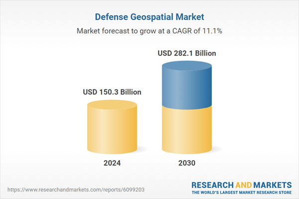
The global market for Defense Geospatial was estimated at US$150.3 Billion in 2024 and is projected to reach US$282.1 Billion by 2030, growing at a CAGR of 11.1% from 2024 to 2030. This comprehensive report provides an in-depth analysis of market trends, drivers, and forecasts, helping you make informed business decisions. The report includes the most recent global tariff developments and how they impact the Defense Geospatial market.

Global Defense Geospatial Market - Key Trends & Drivers Summarized

Why Is Geospatial Intelligence Emerging as a Core Pillar in Modern Defense Operations?

Defense geospatial solutions encompassing satellite imagery, GPS-based navigation, GIS analytics, LiDAR mapping, and real-time situational intelligence have become integral to modern military strategy and national security operations. These technologies provide real-time, location-specific data for command-and-control functions, surveillance, threat detection, border monitoring, and mission planning. As defense ecosystems transition to network-centric warfare and multi-domain operations, geospatial intelligence (GEOINT) is playing a pivotal role in enabling.

Modern combat scenarios, asymmetric threats, and cross-border tensions require constant, high-resolution awareness of terrain, movement, infrastructure, and environmental variables. Geospatial platforms address this need by converting raw spatial data into actionable insights supporting logistics, targeting, force deployment, and disaster response. The incorporation of space-based sensors, unmanned systems, and AI-enabled geospatial analytics is transforming geospatial intelligence from a support function to a strategic enabler of national defense.

What Technologies and Platforms Are Redefining Defense Geospatial Intelligence Capabilities?

The defense geospatial market is evolving rapidly through the integration of multi-sensor fusion, artificial intelligence (AI), edge analytics, and high-performance computing. Synthetic Aperture Radar (SAR) and hyperspectral imaging from low-earth orbit (LEO) satellites are providing all-weather, day-and-night visibility into terrain and activities across adversarial zones. Unmanned Aerial Vehicles (UAVs), equipped with electro-optical and thermal sensors, are extending tactical geospatial capabilities in real-time battlefield reconnaissance.

AI and machine learning algorithms are automating target recognition, anomaly detection, and change analysis in geospatial datasets, dramatically reducing interpretation time and enabling rapid response. Geographic Information Systems (GIS) platforms, integrated with battlefield management systems, now offer 3D terrain modeling, route optimization, and infrastructure mapping for mission-critical planning. Augmented Reality (AR) overlays are being deployed in combat training and navigation systems to enhance situational awareness in contested environments.

Advanced data fusion frameworks are combining geospatial feeds with human intelligence (HUMINT), signals intelligence (SIGINT), and open-source intelligence (OSINT) to generate multidimensional intelligence products. Defense geospatial cloud architectures and sovereign satellite constellations are enabling countries to secure their intelligence lifelines while reducing reliance on foreign surveillance data. These innovations are establishing a new paradigm of precision, autonomy, and interoperability in defense intelligence workflows.

Who Are the Primary Stakeholders and How Are Regional Defense Forces Adopting Geospatial Capabilities?

The key stakeholders in defense geospatial markets include military intelligence agencies, defense ministries, satellite operators, GIS software providers, defense contractors, and space agencies. End-users span air forces, navies, army intelligence divisions, border protection agencies, and homeland security departments. Governments are investing in sovereign earth observation programs to reduce dependency on allied intelligence and ensure round-the-clock visibility of strategic regions.

In the United States, agencies like NGA (National Geospatial-Intelligence Agency) and DoD command centers use geospatial systems to coordinate overseas deployments, disaster response, and counterterrorism operations. NATO forces utilize interoperable geospatial platforms to support joint operations and secure tactical communication networks. In Europe, countries like France, Germany, and the UK are scaling up indigenous satellite imaging and GIS-driven military planning systems.

In Asia-Pacific, China and India are aggressively developing sovereign satellite surveillance programs and geospatial command centers to support regional military dominance and border integrity. Israel, South Korea, and Japan are deploying high-resolution imagery and UAV-based GIS platforms for precision strike and real-time monitoring of strategic installations. Emerging economies in Latin America, Africa, and the Middle East are adopting cost-efficient geospatial solutions through dual-use civilian-military collaborations and international satellite data agreements.

What Is Driving the Expansion of the Global Defense Geospatial Market?

The growth in the defense geospatial market is driven by increasing geopolitical instability, expanding defense budgets, and the operational need for precise, persistent, and secure intelligence. As threats evolve from conventional warfare to cyber-physical attacks and grey-zone conflicts, geospatial intelligence enables early threat identification, pre-emptive response, and full-spectrum situational dominance.

The convergence of satellite technology, drone surveillance, and AI analytics is reducing the latency and opacity of military intelligence, allowing for faster, more accurate decision-making. National security priorities, coupled with advancements in small satellite constellations and real-time data relay, are further accelerating demand for responsive geospatial platforms.

Multilateral defense alliances, international arms agreements, and military modernization programs are fueling cross-border procurement of geospatial solutions and training systems. As digital battlefield architectures evolve and spatial data becomes integral to command decisions, the defense geospatial market is poised for long-term, strategic growth, underpinning both operational readiness and national sovereignty.

Key Insights:

  • Market Growth: Understand the significant growth trajectory of the Geographic Information System segment, which is expected to reach US$164.8 Billion by 2030 with a CAGR of a 10.5%. The Global Positioning System segment is also set to grow at 12.6% CAGR over the analysis period.
  • Regional Analysis: Gain insights into the U.S. market, valued at $40.9 Billion in 2024, and China, forecasted to grow at an impressive 14.9% CAGR to reach $58.0 Billion by 2030. Discover growth trends in other key regions, including Japan, Canada, Germany, and the Asia-Pacific.

Why You Should Buy This Report:

  • Detailed Market Analysis: Access a thorough analysis of the Global Defense Geospatial Market, covering all major geographic regions and market segments.
  • Competitive Insights: Get an overview of the competitive landscape, including the market presence of major players across different geographies.
  • Future Trends and Drivers: Understand the key trends and drivers shaping the future of the Global Defense Geospatial Market.
  • Actionable Insights: Benefit from actionable insights that can help you identify new revenue opportunities and make strategic business decisions.

Key Questions Answered:

  • How is the Global Defense Geospatial Market expected to evolve by 2030?
  • What are the main drivers and restraints affecting the market?
  • Which market segments will grow the most over the forecast period?
  • How will market shares for different regions and segments change by 2030?
  • Who are the leading players in the market, and what are their prospects?

Report Features:

  • Comprehensive Market Data: Independent analysis of annual sales and market forecasts in US$ Million from 2024 to 2030.
  • In-Depth Regional Analysis: Detailed insights into key markets, including the U.S., China, Japan, Canada, Europe, Asia-Pacific, Latin America, Middle East, and Africa.
  • Company Profiles: Coverage of players such as Airbus Defence and Space, BAE Systems, Bentley Systems, BlackSky, and more.
  • Complimentary Updates: Receive free report updates for one year to keep you informed of the latest market developments.

Some of the 42 companies featured in this Defense Geospatial market report include:

  • Airbus Defence and Space
  • BAE Systems
  • Bentley Systems
  • BlackSky
  • Capella Space
  • Collins Aerospace
  • Esri
  • Garmin
  • General Dynamics
  • Hexagon AB
  • L3Harris Technologies
  • Leidos
  • Lockheed Martin
  • Maxar Technologies
  • Northrop Grumman
  • Planet Labs
  • Raytheon Technologies
  • Saab AB
  • Thales Group
  • Trimble

This edition integrates the latest global trade and economic shifts as of June 2025 into comprehensive market analysis. Key updates include:

  • Tariff and Trade Impact: Insights into global tariff negotiations across 180+ countries, with analysis of supply chain turbulence, sourcing disruptions, and geographic realignment. Special focus on 2025 as a pivotal year for trade tensions, including updated perspectives on the Trump-era tariffs.
  • Adjusted Forecasts and Analytics: Revised global and regional market forecasts through 2030, incorporating tariff effects, economic uncertainty, and structural changes in globalization. Includes segmentation by product, technology, type, material, distribution channel, application, and end-use, with historical analysis since 2015.
  • Strategic Market Dynamics: Evaluation of revised market prospects, regional outlooks, and key economic indicators such as population and urbanization trends.
  • Innovation & Technology Trends: Latest developments in product and process innovation, emerging technologies, and key industry drivers shaping the competitive landscape.
  • Competitive Intelligence: Updated global market share estimates for 2025, competitive positioning of major players (Strong/Active/Niche/Trivial), and refined focus on leading global brands and core players.
  • Expert Insight & Commentary: Strategic analysis from economists, trade experts, and domain specialists to contextualize market shifts and identify emerging opportunities.
  • Complimentary Update: Buyers receive a free July 2025 update with finalized tariff impacts, new trade agreement effects, revised projections, and expanded country-level coverage.

Table of Contents

I. METHODOLOGYII. EXECUTIVE SUMMARY
1. MARKET OVERVIEW
  • Influencer Market Insights
  • World Market Trajectories
  • Tariff Impact on Global Supply Chain Patterns
  • Defense Geospatial - Global Key Competitors Percentage Market Share in 2025 (E)
  • Competitive Market Presence - Strong/Active/Niche/Trivial for Players Worldwide in 2025 (E)
2. FOCUS ON SELECT PLAYERS
3. MARKET TRENDS & DRIVERS
  • Increased Use of Real-Time Terrain Intelligence Throws the Spotlight on Geospatial Tools in Defense Operations
  • Expansion of Satellite and UAV-Based Imaging Drives Demand for High-Resolution Mapping Systems
  • OEM Development of AI-Enhanced Geospatial Analytics Strengthens Military Planning and Reconnaissance
  • Growth in Multi-Domain Operations and Sensor Fusion Propels Integration of Geospatial Intelligence Systems
  • Rising Importance of Geospatial Awareness in Cyber, Space, and Information Warfare Fuels Platform Adoption
  • OEM Partnerships With National Defense Agencies Enhance Interoperability of Mapping and Command Systems
  • Expansion of 3D Terrain Modeling and LiDAR Integration Supports Mission Simulation and Navigation Accuracy
  • OEM Focus on Cloud-Based Geospatial Platforms Enhances Scalability and Data Centralization
  • Surge in Border Surveillance and Counter-Terrorism Operations Accelerates Investment in Tactical GIS Systems
  • Increased Use of Augmented Reality for Combat Training and Terrain Familiarization Expands Geospatial Applications
  • OEM Development of Real-Time Mapping for Troop Movement and Asset Tracking Supports Battlefield Coordination
  • Integration of Geospatial Data With ISR and Targeting Systems Enhances Decision-Making Speed
  • Growth in Space-Based Surveillance Capabilities Drives Procurement of Defense Satellite Imagery Tools
  • OEM Emphasis on Secure Data Transmission and Encrypted Imagery Access Enhances Operational Security
  • Rising Demand for Disaster Response and Climate Risk Mapping in Military Missions Expands Use Cases
  • Global Militarization of the Arctic and Maritime Zones Spurs Geospatial Intelligence Expansion
  • Focus on Precision-Guided Munitions and Autonomous Systems Increases Reliance on Geospatial Inputs
  • OEM Collaboration With Defense Contractors for Ground Control Software Enhances System Modularity
  • Development of Integrated Command Centers With Embedded Geospatial Displays Drives Modern Warfare Readiness
  • OEM Innovation in Lightweight and Soldier-Carried Geospatial Devices Improves Tactical Edge Mapping Capabilities
4. GLOBAL MARKET PERSPECTIVE
  • TABLE 1: World Defense Geospatial Market Analysis of Annual Sales in US$ Million for Years 2015 through 2030
  • TABLE 2: World Recent Past, Current & Future Analysis for Defense Geospatial by Geographic Region - USA, Canada, Japan, China, Europe, Asia-Pacific, Latin America, Middle East and Africa Markets - Independent Analysis of Annual Sales in US$ Million for Years 2024 through 2030 and % CAGR
  • TABLE 3: World Historic Review for Defense Geospatial by Geographic Region - USA, Canada, Japan, China, Europe, Asia-Pacific, Latin America, Middle East and Africa Markets - Independent Analysis of Annual Sales in US$ Million for Years 2015 through 2023 and % CAGR
  • TABLE 4: World 15-Year Perspective for Defense Geospatial by Geographic Region - Percentage Breakdown of Value Sales for USA, Canada, Japan, China, Europe, Asia-Pacific, Latin America, Middle East and Africa Markets for Years 2015, 2025 & 2030
  • TABLE 5: World Recent Past, Current & Future Analysis for Geographic Information System by Geographic Region - USA, Canada, Japan, China, Europe, Asia-Pacific, Latin America, Middle East and Africa Markets - Independent Analysis of Annual Sales in US$ Million for Years 2024 through 2030 and % CAGR
  • TABLE 6: World Historic Review for Geographic Information System by Geographic Region - USA, Canada, Japan, China, Europe, Asia-Pacific, Latin America, Middle East and Africa Markets - Independent Analysis of Annual Sales in US$ Million for Years 2015 through 2023 and % CAGR
  • TABLE 7: World 15-Year Perspective for Geographic Information System by Geographic Region - Percentage Breakdown of Value Sales for USA, Canada, Japan, China, Europe, Asia-Pacific, Latin America, Middle East and Africa for Years 2015, 2025 & 2030
  • TABLE 8: World Recent Past, Current & Future Analysis for Global Positioning System by Geographic Region - USA, Canada, Japan, China, Europe, Asia-Pacific, Latin America, Middle East and Africa Markets - Independent Analysis of Annual Sales in US$ Million for Years 2024 through 2030 and % CAGR
  • TABLE 9: World Historic Review for Global Positioning System by Geographic Region - USA, Canada, Japan, China, Europe, Asia-Pacific, Latin America, Middle East and Africa Markets - Independent Analysis of Annual Sales in US$ Million for Years 2015 through 2023 and % CAGR
  • TABLE 10: World 15-Year Perspective for Global Positioning System by Geographic Region - Percentage Breakdown of Value Sales for USA, Canada, Japan, China, Europe, Asia-Pacific, Latin America, Middle East and Africa for Years 2015, 2025 & 2030
  • TABLE 11: World Recent Past, Current & Future Analysis for Remote Sensing by Geographic Region - USA, Canada, Japan, China, Europe, Asia-Pacific, Latin America, Middle East and Africa Markets - Independent Analysis of Annual Sales in US$ Million for Years 2024 through 2030 and % CAGR
  • TABLE 12: World Historic Review for Remote Sensing by Geographic Region - USA, Canada, Japan, China, Europe, Asia-Pacific, Latin America, Middle East and Africa Markets - Independent Analysis of Annual Sales in US$ Million for Years 2015 through 2023 and % CAGR
  • TABLE 13: World 15-Year Perspective for Remote Sensing by Geographic Region - Percentage Breakdown of Value Sales for USA, Canada, Japan, China, Europe, Asia-Pacific, Latin America, Middle East and Africa for Years 2015, 2025 & 2030
  • TABLE 14: World Recent Past, Current & Future Analysis for Surface Analysis by Geographic Region - USA, Canada, Japan, China, Europe, Asia-Pacific, Latin America, Middle East and Africa Markets - Independent Analysis of Annual Sales in US$ Million for Years 2024 through 2030 and % CAGR
  • TABLE 15: World Historic Review for Surface Analysis by Geographic Region - USA, Canada, Japan, China, Europe, Asia-Pacific, Latin America, Middle East and Africa Markets - Independent Analysis of Annual Sales in US$ Million for Years 2015 through 2023 and % CAGR
  • TABLE 16: World 15-Year Perspective for Surface Analysis by Geographic Region - Percentage Breakdown of Value Sales for USA, Canada, Japan, China, Europe, Asia-Pacific, Latin America, Middle East and Africa for Years 2015, 2025 & 2030
  • TABLE 17: World Recent Past, Current & Future Analysis for Network Analysis by Geographic Region - USA, Canada, Japan, China, Europe, Asia-Pacific, Latin America, Middle East and Africa Markets - Independent Analysis of Annual Sales in US$ Million for Years 2024 through 2030 and % CAGR
  • TABLE 18: World Historic Review for Network Analysis by Geographic Region - USA, Canada, Japan, China, Europe, Asia-Pacific, Latin America, Middle East and Africa Markets - Independent Analysis of Annual Sales in US$ Million for Years 2015 through 2023 and % CAGR
  • TABLE 19: World 15-Year Perspective for Network Analysis by Geographic Region - Percentage Breakdown of Value Sales for USA, Canada, Japan, China, Europe, Asia-Pacific, Latin America, Middle East and Africa for Years 2015, 2025 & 2030
  • TABLE 20: World Recent Past, Current & Future Analysis for Geo Visualization by Geographic Region - USA, Canada, Japan, China, Europe, Asia-Pacific, Latin America, Middle East and Africa Markets - Independent Analysis of Annual Sales in US$ Million for Years 2024 through 2030 and % CAGR
  • TABLE 21: World Historic Review for Geo Visualization by Geographic Region - USA, Canada, Japan, China, Europe, Asia-Pacific, Latin America, Middle East and Africa Markets - Independent Analysis of Annual Sales in US$ Million for Years 2015 through 2023 and % CAGR
  • TABLE 22: World 15-Year Perspective for Geo Visualization by Geographic Region - Percentage Breakdown of Value Sales for USA, Canada, Japan, China, Europe, Asia-Pacific, Latin America, Middle East and Africa for Years 2015, 2025 & 2030
  • TABLE 23: World Recent Past, Current & Future Analysis for Military Logistics by Geographic Region - USA, Canada, Japan, China, Europe, Asia-Pacific, Latin America, Middle East and Africa Markets - Independent Analysis of Annual Sales in US$ Million for Years 2024 through 2030 and % CAGR
  • TABLE 24: World Historic Review for Military Logistics by Geographic Region - USA, Canada, Japan, China, Europe, Asia-Pacific, Latin America, Middle East and Africa Markets - Independent Analysis of Annual Sales in US$ Million for Years 2015 through 2023 and % CAGR
  • TABLE 25: World 15-Year Perspective for Military Logistics by Geographic Region - Percentage Breakdown of Value Sales for USA, Canada, Japan, China, Europe, Asia-Pacific, Latin America, Middle East and Africa for Years 2015, 2025 & 2030
  • TABLE 26: World Recent Past, Current & Future Analysis for Intelligence Gathering by Geographic Region - USA, Canada, Japan, China, Europe, Asia-Pacific, Latin America, Middle East and Africa Markets - Independent Analysis of Annual Sales in US$ Million for Years 2024 through 2030 and % CAGR
  • TABLE 27: World Historic Review for Intelligence Gathering by Geographic Region - USA, Canada, Japan, China, Europe, Asia-Pacific, Latin America, Middle East and Africa Markets - Independent Analysis of Annual Sales in US$ Million for Years 2015 through 2023 and % CAGR
  • TABLE 28: World 15-Year Perspective for Intelligence Gathering by Geographic Region - Percentage Breakdown of Value Sales for USA, Canada, Japan, China, Europe, Asia-Pacific, Latin America, Middle East and Africa for Years 2015, 2025 & 2030
  • TABLE 29: World Recent Past, Current & Future Analysis for Battlefield Management by Geographic Region - USA, Canada, Japan, China, Europe, Asia-Pacific, Latin America, Middle East and Africa Markets - Independent Analysis of Annual Sales in US$ Million for Years 2024 through 2030 and % CAGR
  • TABLE 30: World Historic Review for Battlefield Management by Geographic Region - USA, Canada, Japan, China, Europe, Asia-Pacific, Latin America, Middle East and Africa Markets - Independent Analysis of Annual Sales in US$ Million for Years 2015 through 2023 and % CAGR
  • TABLE 31: World 15-Year Perspective for Battlefield Management by Geographic Region - Percentage Breakdown of Value Sales for USA, Canada, Japan, China, Europe, Asia-Pacific, Latin America, Middle East and Africa for Years 2015, 2025 & 2030
III. MARKET ANALYSIS
UNITED STATES
  • Defense Geospatial Market Presence - Strong/Active/Niche/Trivial - Key Competitors in the United States for 2025 (E)
CANADA
JAPAN
  • Defense Geospatial Market Presence - Strong/Active/Niche/Trivial - Key Competitors in Japan for 2025 (E)
CHINA
  • Defense Geospatial Market Presence - Strong/Active/Niche/Trivial - Key Competitors in China for 2025 (E)
EUROPE
  • Defense Geospatial Market Presence - Strong/Active/Niche/Trivial - Key Competitors in Europe for 2025 (E)
FRANCE
  • Defense Geospatial Market Presence - Strong/Active/Niche/Trivial - Key Competitors in France for 2025 (E)
GERMANY
  • Defense Geospatial Market Presence - Strong/Active/Niche/Trivial - Key Competitors in Germany for 2025 (E)
ITALY
UNITED KINGDOM
  • Defense Geospatial Market Presence - Strong/Active/Niche/Trivial - Key Competitors in the United Kingdom for 2025 (E)
SPAINRUSSIAREST OF EUROPE
ASIA-PACIFIC
  • Defense Geospatial Market Presence - Strong/Active/Niche/Trivial - Key Competitors in Asia-Pacific for 2025 (E)
AUSTRALIA
  • Defense Geospatial Market Presence - Strong/Active/Niche/Trivial - Key Competitors in Australia for 2025 (E)
INDIA
  • Defense Geospatial Market Presence - Strong/Active/Niche/Trivial - Key Competitors in India for 2025 (E)
SOUTH KOREAREST OF ASIA-PACIFIC
LATIN AMERICA
  • Defense Geospatial Market Presence - Strong/Active/Niche/Trivial - Key Competitors in Latin America for 2025 (E)
ARGENTINABRAZILMEXICOREST OF LATIN AMERICA
MIDDLE EAST
  • Defense Geospatial Market Presence - Strong/Active/Niche/Trivial - Key Competitors in Middle East for 2025 (E)
IRANISRAELSAUDI ARABIAUNITED ARAB EMIRATESREST OF MIDDLE EAST
AFRICA
  • Defense Geospatial Market Presence - Strong/Active/Niche/Trivial - Key Competitors in Africa for 2025 (E)
IV. COMPETITION

Companies Mentioned (Partial List)

A selection of companies mentioned in this report includes, but is not limited to:

  • Airbus Defence and Space
  • BAE Systems
  • Bentley Systems
  • BlackSky
  • Capella Space
  • Collins Aerospace
  • Esri
  • Garmin
  • General Dynamics
  • Hexagon AB
  • L3Harris Technologies
  • Leidos
  • Lockheed Martin
  • Maxar Technologies
  • Northrop Grumman
  • Planet Labs
  • Raytheon Technologies
  • Saab AB
  • Thales Group
  • Trimble

Table Information